Easy Mountaineering Uzbekistan
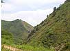
We invite you to the beautiful mountain area of Uzbekistan in Bostanlik district of Tashkent province. This place is situated along the
Qizilsuv Mountain River on the southern
slopes of the
Karjantau ridge
of the West Tien-Shan.
Historical information
According to some local information sources there was formerly the
Kazakh village. The village was at least 100 years old, when it was moved by
authorities to another locality. Majestic sceneries, good climate conditions,
ethnic features, absence of industrial enterprises and proximity of capital had
caused transformation of this valley between mountains to recreation area.
During several soviet decades, summer camps for children, pension and several
recreation zones were built at the valley.
Climate and seasons
Surrounding foothills and mountains influence the climate of the area.
Winter is cold and wet. The river cools down the air in summer. Downpours fall
in spring and autumn creating menace of landslide and mudflow. The temperature
rises as high as 40 C (Celsius) in summer, and falls to -15 C in winter. Located
nearby,
Charvak water
reservoir strongly influences sub-regional climate.
Natural environment
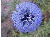
Surrounding area is a territory where a great number of
bushes,
flowers
and trees grow, including legally protected spices. Medicinal plants
have a special status, their harvesting being legally regulated. Present animals include bears, wolves, foxes and wild sheep. Eagles, partridges, pigeons and fish are representatives of other interesting biological species.
Historical sites
The nearest historical attraction is Khidjikent bazaar boshi (VI-VII,
IX-XII) - the site is located on the road to the area, and include
petroglyphic paintings,
ancient plane-trees,
waterfall and grottos.
Natural sites
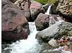
Qizilsuv waterfalls (in Uzbek 'Qizilsuv' means Red water) - pictorial
cascades, confluent of Qizilsuv Mountain River, about 9 km up-stream from the
area.
Arkutsay - exposure of loess stratum. The site is 4 km east of the area,
on the right bank of the Ugam river. Section of the formation represents the
wall of a small landslide breakaway and is a stratum of interstratifying
loess-like loams and fossil soils horizons. The section is unique as it exposes
more than 80 m thick deposition of rocks.
Tourism infrastructure and services
The nearest big city is Tashkent, the capital of Uzbekistan, which is as
far as 90 km (about 1.5 hours) away from the area. Large neighboring
settlements are village Charvak located 7 km away, Humsan located 12 km away and
the district centre Gazalkent - 25 km away. The nearest international airport is
in Tashkent. The nearest railway station is Khodjikent, from where it takes 15
min. to get to the area by rented bus or taxi.
Other centers of tourism, Chimgan and Brichmulla, are located 40 km. and
60 km. from the area, respectively.
The area has good accessibility in spring/summertime. It is possible to use
a car and minibus. Alternative route are railway Tashkent-Khodjikent (4 times a
day) and continue to the area by rented bus or taxi.
At the neighboring villages one can buy souvenirs from local
handicraftsman, try and eat locally cooked foot, in particular: dairy products
(koumiss, kurt, curds, clabber) and pancakes 'yupka' and 'catlama'. Local
population is friendly and hospitable towards visitors. Uzbek and Russian
language are widely used (sometimes communication in English and French is
possible).
Roads leading to the area are paved with asphalt and of average
quality. Electricity lines are installed. Water supply is provided. Telephone
communication is available. The most effective is the cellular communication.
Internet is not provided.
Routes and tourism opportunities
Mountaineering: Route to the highest peak of the Karjantau
ridge - the peak
Mingbulak (2,628 m).
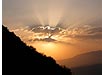
Panoramic view from the peak to the Ugam, Pskent and Chatkal ridges
of the West Tien-Shan; Charvak and Khodjikent water reservoirs and the Valley of
Chirchik River.
Hiking:
Route #1. Ascent to
Qizilsuv waterfalls
- the pictorial cascades that flow at the sinuous river gorges of Qizilsuv
Mountain River, about 9 km up-stream from campsite.
Route #2. Walking on the slopes, ascending to a panorama
point of the Karjantau ridge, and then to Mingbulak pass (2,100 m). The word
'Mingbulak' means 'Thousand-springs'. The peek and pass acquired their names
from numerous springs that in actuality exist on the slopes near to Mingbulak
pass.
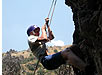
Rock Climbing:
Route #1 plus
climbing to the rocks surrounding the waterfalls.
Horseback ridings to the head water of the Arkutsay
Mountain River. View to the valley of the Chirchik River.
Other activities available:
• Folklore and gastronomy;
• Relaxation, rest in wildlife, ecologic tours over the area;
• Fishing, harvesting of medicinal plants.
|